Institut Perubahan Iklim
Institut Perubahan Iklim
Institute of Climate Change
- UTAMA
- DIREKTORI
- Pengurusan Tertinggi | Top Management
- Pentadbiran | Administrative
- Pusat Pencerapan Bumi | Earth Observation Centre
- Pusat Sains Angkasa | Space Science Centre
- Pusat Sistem Perubahan Iklim Tropika | Centre for Tropical Climate Change System
- Pusat Pengurusan Alam Sekitar | Environmental Management Centre
- FELO
- SISWAZAH
- PENYELIDIKAN
- ACARA
- Persidangan
- Siri Seminar IPI
- PENGHIJAUAN MALAYSIA SEJUTA POKOK
- 2024 Bengkel Training of Trainers (ToT) Penghijauan Malaysia: Koperasi Prihatin Sejuta Pokok.
- Hari Denai Alam
- Bengkel Penghijauan Malaysia Bersama Sekolah
- Program Penghijauan Malaysia Koperasi Prihatin Sejuta Pokok
- Majlis Pelancaran Penghijauan Malaysia
- Majlis Prapelancaran Penghijauan Malaysia: Koperasi Prihatin Sejuta Pokok
- AKEPT-UKM Webinar Series
- Latihan
- ALUMNI
- KELESTARIAN
- GALERI

EOC IS ONE OF THE RESEARCH CENTRE IN UKM WHO ARE EXPERT IN GEOSPATIAL DATA ANALYST
About Us
The Earth Observation Centre (EOC) is a centre of excellence under the Institute of Climate Change. The main focus is conducts research on the impacts of global change through the application of Remote Sensing and Geographical Information System (GIS). This centre pools researchers from the various fields such as social sciences, engineering, science and technology, geology and biological.
EOC takes an interdisciplinary approach to geography, linking several disciplines involving both social sciences and biophysical science. Members of EOC have been successful in obtaining international and national grants to conduct research in Southeast Asia on such issues such as Land Use and Land Cover Change in Malaysia, Forest Cover Change and Forest Assessment and Management in Southeast Asia, Deforestation and Missing Sink for Carbon, Sediment Plume in Selangor and Tropical Forest Assessment and Management. The University programmes that use RS / GIS laboratories at EOC include geography, engineering, geology, marine science, environmental science, hydrology and conservation biology.
EOC uses Satellite Remote Sensing methods as a tool to monitor global variability such as:
-
Dynamic of Land use Change
-
Deforestation and Degradation
-
Vegetation dynamism
-
Water condition
-
Atmospheric pollution
-
Desertification process
EOC takes an interdisciplinary approach to geography,
linking several disciplines involving both social
sciences and biophysical sciences
Previous Project/Research
| No. | Project Name | Funder |
| 1. | Carbon Loss Assessment from Tropical Forest Degradation Caused by Selective Logging Using High Resolution Satellite Imagery | Ministry of Higher Education |
| 2. | Assessing Impact of Forest Degradation and Forest Change Caused by Selective Logging Using High Resolution Satellite Image and UAV Multispectral | Ministry of Higher Education |
| 3. | Identification of Degradation Areas in the State of Perak and Kedah Through Geospatial Imagery Database | Yayasan Hasanah |
| 4. | Program Data Alam Sekitar | Dept of Environment, Ministry of Natural Resources & Environment |
| 5. | National Coastal Erosion Study For Malaysia | Department of Irrigation and Drainage |
| 6. | Physical Impacts of Sea Level Rise Due to the Changes in Coastal and Climate Systems | Ministry of Higher Education |
| 7. | The Integrated Shoreline Management Plan For The West Coast Of Johor | Department of Irrigation and Drainage |
| 8. | Shoreline Management for Iskandar Malaysia | IRDA |
| 9. | Detailed Environmental Impact Assessment (Deia) For The Proposed Construction Of New Townships Nusajaya West (Gerbang Nusajaya), Johor | UEM Land Sdn Bhd |
| 10. | Analisis Perubahan Garis Pantai Menggunakan Imej Satelit | Dr. Nik & Associates Sdn. Bhd |
| 11. | Environmental Master Plan Nusajaya | UEM Land Berhad |
| 12. | Development of a comprehensive Marine Energy Atlas for Malaysia | MOSTI |
| 13. | Deforestation and Impact On The Environment in The Iskandar Development Region, Mukim Pulai, Bandar Nusajaya, Daerah Johor Bahru | UEM Land Sdn Bhd |
| 14. | Provision Of Consultant Services In Relation To South Johor Economic Region (SJER) | Khazanah Nasional Berhad |
Research Output
- Baseline study in biodiversity
- A geo-database for mangrove/ forest biodiversity (flora and fauna) that is accessible to various stakeholders.
- An online mangrove/forest distribution and spatial analysis for authorities.
- Mangrove/forest conservation outreach and awareness programme supported by web-based database that is also sustained by continuing activities and management policies.
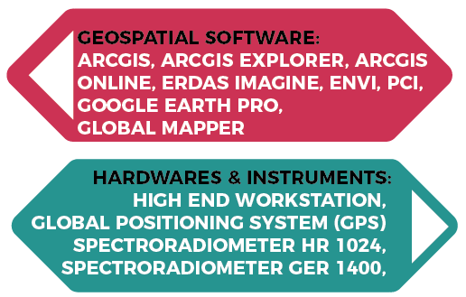
Technical Capabilities